-
Coastal and freshwater sites of significance for indigenous birds in the Wellington region
Policy 23 of the Wellington Regional Policy Statement directs regional and district plans to "identify ecosystems ... with significant indigenous biodiversity values" in coastal and freshwater habitats in the Wellington…
alarm Published 30 Sept 2013 -
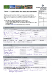
Submission Form for the Southern Landfill Resource Consent
This is the form who anyone to submit feedback on a notified resource consent that affects them.
alarm Published 17 Sept 2013 -
3 August 2013 to 13 September 2013
This document contains the decisions made under delegated authority on non-notified resource consent applications covering the period of 3 August to 13 September.
alarm Published 13 Sept 2013 -
s92: Further Information Response (2)
This document contains further information in the form of the Flood Protection Activities on Aquatic and Riparian Ecology report and the Environmental Monitoring Plan.
alarm Published 30 Aug 2013 -
Appendix C: Title Schedule
This document contains the title schedules for land owners in the application area for WGN140054.
alarm Published 22 Aug 2013 -
Appendix L: Regional Objectives and Policies
This document contains the regional objectives and policies that concern consent WGN140054.
alarm Published 22 Aug 2013 -
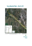
Appendix D: Ōtaki River Design Meander
This document contains the design channel meander of the Ōtaki River.
alarm Published 21 Aug 2013 -
Appendix A: Consent Application Forms
This document contains the original consent application forms for WGN140054.
alarm Published 20 Aug 2013